North at the Top Was a Choice
Map orientation is a convention, not a law. Learn when turning a map helps match a route to the view, and how to keep geographic direction clear.
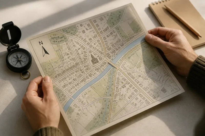
The common mistake with map orientation is to treat the page’s top edge as the top of the world. Turn a printed town plan or rotate a screen, and the streets stay put while the eye starts to notice different alignments. North-up is a useful convention, not a natural feature of the landscape.
That distinction matters when you are matching a map to the view in front of you or following a route through an unfamiliar place. The map’s north arrow, a known landmark, and the direction of a road or river can help you turn the page without confusing page-left with west.
Why is north usually at the top of a map?
There is no universal rule that puts north at the top. Maps have been arranged in different ways to serve their subjects and readers, with routes, settlements, coastlines, or other features given prominence according to the map’s purpose.
North-up became a familiar convention through the way maps and navigation practices were used and circulated. Compass directions offered a practical reference for describing places, and repeated exposure to north-up maps may have helped establish that arrangement as an expectation. It remains a convention rather than a requirement.
On a north-up map, east lies to the right and west to the left. Those page positions follow from the chosen orientation; the ground itself has no upper edge.
When a map looks unexpected, check its north arrow before deciding that the place is arranged unusually.
What changes when you rotate a map?
Rotation changes which lines and connections stand out to the eye. A road that crosses a north-up page diagonally may become an easy-to-follow horizontal line when the map is turned to match the direction of travel.
The mapped features keep the same relationships to one another. A bridge remains beside the same river bend, and a church remains at the same junction, even if those features now sit at different angles on the page.
Turning a map does not show which way is uphill. Elevation is represented by information such as contour lines or spot heights, not by whether a route runs toward the top or bottom of the sheet.
Keep the north arrow in view when you turn a map, so page direction does not become geographic direction.
When is a rotated map useful?
A map can be easier to match to your surroundings when a prominent feature runs in the same direction on the page as it does in front of you. At a canal bridge, for instance, you might turn a local plan until the canal follows the direction of the waterway you can see, then use a bend or crossing to confirm the match.
A walking-route map may also be arranged to make the route’s sequence easier to follow, even if north points sideways. The north arrow still matters: it preserves the link between the page and compass directions.
A second orientation is most helpful when it answers a different question. A north-up view can help compare locations across a wider area; a turned view can make a nearby route or connection easier to trace.
How can you check a map’s orientation?
- Check the north arrow. If it is visible, use it to identify geographic north; if it is missing, avoid treating the page’s top as north and look for a compass mark or another map view.
- Find a named road or river. If its direction matches the feature you can see, use it as an initial alignment; if it does not, rotate the map or check whether you have identified the right feature.
- Look for a second landmark. If a bridge, bend, or junction also matches its mapped position, keep that orientation; if it conflicts, reconsider the first match.
- Read the legend and scale bar. If the map includes them, use the legend to interpret symbols and the scale bar to understand mapped distance; if either is absent, avoid inferring those details from the map alone.
- Check the phone’s compass symbol. If it indicates north-up, use the top edge as north; if the view rotates or the symbol points in the direction of travel, follow the app’s orientation cue instead.
- Separate page direction from slope. If contour lines or spot heights are shown, use them to assess elevation; if they are not, do not infer uphill or downhill from the route’s position on the screen.
What can a rotated map reveal about a place?
A change of orientation can make a route, river, or line of buildings easier to follow as a connected feature. It may also show how a town’s streets meet a railway or a river crossing more clearly than a fixed north-up view does. That visual emphasis helps you inspect relationships; it does not explain why they came to be.
Say you have a north-up plan of a village square, a church, and a main street. The street runs diagonally, the church stands beside it, and a road junction lies beyond the square. You turn the plan until the street points in the same direction as the street visible from the square, then check that the church and junction fall on the expected sides. If both landmarks match, the turned view gives you a clearer way to describe their spatial relationship; if either falls on the wrong side, the alignment is probably off and you should check the map again.
The map’s design still shapes what attracts attention. A route map gives the route prominence, while a town plan may place one district near the edge. Turning the image can change what you notice first, but it does not remove those choices.
Which map orientation should you use?
Should every map have north at the top?
No. North-up is a convenient shared reference, while a route or local view may be clearer in another orientation. A visible north arrow lets readers distinguish page position from compass direction.
How do you orient a paper map to the ground?
Turn the map until a recognizable feature, such as a road or river, runs in the same direction as the feature in front of you. Check the match against another landmark, such as a bridge or bend, before relying on that alignment.
Does rotating a map change its scale or projection?
No. Rotation changes the map’s position on the page, not its scale or projection. It retains the same mapped area and the same characteristics it had before turning.
Why does a phone map rotate as I walk?
Some map apps rotate the display using a compass or direction-of-travel setting; others keep north at the top. Check the compass symbol or orientation setting to see which reference the app is using.
How does map orientation help you read a place?
Map orientation is a choice about how to look at the same mapped relationships. North-up offers a common reference, while a rotated view can help match a nearby street, waterway, or route to what you see on the ground.
For a clearer reading, identify the north mark, align a recognizable feature, and confirm it with another landmark. Using map orientation this way helps you describe where things lie without letting the page’s top edge decide what counts as north.